- Home
- Newsletters
- Maps and Guidebook
- Join Us
- Calendar
- Contact, FAQ
- Bylaws
- Vision
- Links
- Trail alerts, Guide Update
- Overseers Guide
- GIS information

President: Ed Lawrence, cathyed@nationi.net
Secretary: Scott Adams secretary@hike-mst.org
Treasurer: Kirk Bucynski bucynski[at} verizon.net
Webmaster: Steve Tuckerman webmaster@hike-mst.org
If there is a concern with a particular part of the trail you hiked, if you have a particular question, or especially if you can volunteer your time or expertise in one of the four Regions of Mid State Trail, contact one of the following volunteer Regional Managers:
MD border to US 22, Bedford, Blair, southwestern Huntingdon counties: |
US 22 north to PA 192, Huntingdon, Centre, Mifflin, far southwest
Union counties: State College Region , Tom Thwaites, 814 237-7703, Kevin Busko 814-643-4238,statecollege@hike-mst.org |
PA 192 north to PA 414, and West Rim Spur, Union, Clinton, Lycoming,
and far southwest Tioga counties: |
North of PA 414, most of Tioga County: |
|
|
| MSTA Members |
| Visit this group |
A long distance footpath, the longest in Pennsylvania.

Long ago, all trails were footpaths. Then the Spaniards introduced the horse, and later came the bicycle and the automobile. Still later the ATV arrived on the scene. Some people who have created travelways to ride one or more of these items on, have appropriated the term "trail" in naming some of their passages, so now people frequently confuse a natural surface footpath in the trees with a graded stone-covered narrow road. We carry the name Mid State TRAIL for historical reasons, but we are as we always have been, a FOOTPATH welcoming those who WALK.
Our vision statement articulates our reasons behind the placement and occasional relocations of the Mid State Trail.
The MST now stretches from Green Ridge Forest in Maryland, to as spur of the Finger Lake Trail at the New York state line. General route of the Mid State
Trail (as described
in the old 10th edition) is shown on Pennsylvania's
Official Transportation and Tourism Map, 2008 edition. This map is
available free from highway rest areas, or from PENNDOT.
Some relocations and extensions have not yet caught up with the state map, click here for more
info on these.
The footway may always be subject to change as we improve the route. The MST is now longer than Vermont's Long Trail
MST Maps and Guide sets are sold at outing supply or book stores, by mail from the Mid State Trail Association, and online on this Web site. Please check here for more information.
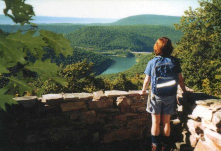
Spectacular vistas from mountain tops, and remoteness of wild forests and streams. Mid State Trail is a pure footpath, if you hike alone you will meet more bears than people.
MST is mostly on public land. Public land partners include Pennsylvania Department of Conservation and Natural Resources (DCNR) Bureau of Forestry, Pennsylvania Game Commission, DCNR Bureau of State Parks, U.S. Army Corps of Engineers, and Pennsylvania Fish and Boat Commission.
MSTA is glad to acknowledge resources provided by DCNR Bureau of Forestry, both directly and through DCNR's significant financial support of MSTA's affiliate, Keystone Trails Association, Trail Care and Trail Crew program.
Some private landowners host sections of MST, especially closer to the Maryland and New York borders. Generally, these landowners may close the trail at any time. It is your responsibility as a hiker to treat the land and its owners with utmost care and respect. Legally, you are a "licensee," not even an "invitee," on these lands (see here for more information on the legal basis of our footpath's use of private land in Pennsylvania). If you behave just as you would expect an uninvited guest on your own property to behave, the path might remain open for generations to come.
The footpath is built, mapped, and maintained by volunteers. It is open to all hikers. It is your trail, too.
 Yes. Buy a map set, hike the footpath, join the Mid State
Trail Association,
Yes. Buy a map set, hike the footpath, join the Mid State
Trail Association,  and/or become an overseer. Keep hiking!
The MST was the first hiking trail in the United States to use metric measure. The second edition of the guide (1973) was completely metric. Metrication is a patriotic measure designed to help end our cultural isolation and ease our chronic balance of payments problems. Click here for more information.
MST has grown beyond initial conceptions. The planned 300 series maps will start with 301 at the Mason-Dixon Line and head in proper numerical order, northward, in positive Cartesian space. These 300 series maps are replacing the 200 series as the old maps sell out.
Mid State Trail passes State College atop the first ridge south of town. The borough of Everett is the largest community directly on the Trail. Hewitt, Williamsburg, Barree, Woolrich, Ramsey, Blackwell, and Nelson also host MST. Drab is close by.
Mid State Trail at Cowanesque Lake passes the main street of what used to be Nelson before it was moved higher out of the inundation area. We also pass through Landrus in Tioga State Forest.
Martin Hill, between PA 326 and SR 3005 south of Rainsburg, Bedford County, in Everett Region, at 829 m.
Presently at Mason-Dixon monument #151, east of Ragged Mountain, in Mann Township, Bedford County. Like most marking the Maryland-Pennsylvania border, this marker is a replacement from the 1902 resurvey. "Y'all come back now, you hear!" This point is a relatively short and pleasant walk on Green Ridge State Forest's Pine Lick Trail from Green Ridge forest headquarters, which has its own exit from Maryland's Interstate 68.
At the intersection of Heffner, Map, and State Line Roads.
MST is not generally an easy trail. The Detweiler Run valley northeast of Alan Seeger Natural Area (Huntingdon Co.) is notorious for ankle-biter rocks. Knee-turners are found on Jackson Trail and MST leading southwest to the Little Juniata (Huntingdon/Centre Cos.). Sharp boulders and knife edges obscured by uncontrollable firecherry characterize MST in SGL 97 south from Everett to PA 326 (Bedford Co.). Glacial mud greets hikers in the Tioga Region (Tioga Co.).
MST climbs over many of Pennsylvania's mountains, but tunnels only through Paddy Mountain in extreme southeast Centre County. Park at Poe Paddy State Park and head northbound (locally east) on MST. Cross Penns Creek on the old railroad bridge and the tunnel is just on the other side.
No.
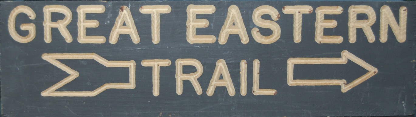
Q: What is the Great Eastern Trail?
A: The Great Eastern Trail is an approximately 1,600+ mile long non-motorized trail system stretching from the Florida/Alabama border to the Finger Lakes Region in Central New York. While it is primarily a foot path, there are a few sections that are multi-use. For instance, the Georgia Pinhoti Trail section allows bike and equestrian use, and parts of the Tuscarora permit multi-use.
Q: How many states does the trail pass through?
A: Nine. Alabama, Georgia, Tennessee, Kentucky, Virginia. West Virginia, Maryland, Pennsylvania, New York.
Q: What makes this trail so special?
A: This trail system is the product of a cooperative grassroots effort coordinated by American Hiking Society. It provides an alternative to the beloved Appalachian Trail. The beauty of the Great Eastern Trail is that it provides connections to more than 10,000 miles of trails including four National Scenic Trails (Florida National Scenic Trail, Appalachian National Scenic Trail, Potomac Heritage National Scenic Trail, and the North Country National Scenic Trail. The trail also passes through some spectacular little-visited areas such as the Cumberland Plateau, Cumberland Gap National Historic Park, the Allegheny Mountains of West Virginia, and remote areas of Virginia and Pennsylvania. The trail will also pass through downtown Chattanooga, Tennessee, and Woolrich, Pennsylvania.
Q: Will this trail become a National Scenic Trail?
A: There are no plans at this time to pursue National Scenic Trail designation.
Q: Will eminent domain be used to acquire land to create this trail.
A: ABSOLUTELY NOT!
Q: Is the trail complete? Can long distance hikers walk the trail now?
A: While there are large segments of the trail that are complete, such as on the Alabama & Georgia Pinhoti Trail and the Tuscarora Trail and most of the Mid State Trail, there are several gaps within the trail that need to be bridged, such as portions of Tioga County, PA, and Steuben County, NY. The trail groups involved are working hard to identify ways to connect together existing trail to make a complete route. Like any long distance trail system, it will take some time to complete this trail.
Q: Has the federal government played a role in creating this trail system?
A: The National Park Service Rivers, Trails and Conservation Assistance program has been assisting in the creation of this trail for over 4 years. Other federal agencies such as the USDA Forest Service and US Army Corps of Engineers manage lands that the trail passes through.
Q: Have other government agencies been involved?
A: Yes. The Cumberland Trail is a linear State Park in Tennessee. Similarly, the Pine Mountain Trail is a linear State Park in Kentucky. The trail also passes through a patchwork of state lands including parks, game lands, and forests. The trail also passes through the City of Chattanooga, Tennessee.
Q: What trail organizations are involved in this effort?
A: Alabama Hiking Trail Society, Alabama Trails Association, Georgia Pinhoti Trail Association, Inc., Cumberland Trail Conference, Pine Mountain Trail Conference, West Virginia Scenic Trails Association, Potomac Appalachian Trail Club (PATC), Mid State Trail Association, Inc., Standing Stone Trail Club, Inc., Keystone Trails Association.
Members of the Finger Lakes Conference, North Country Trail Association, and the Florida Trail Association have also been involved in this cooperative effort. American Hiking Society has played a coordinating role in creating this trail system.
Q: How will this trail be governed?
A: Local rule applies. The fact that the Great Eastern Trail is being created and publicized does not change the identity of the existing trails that comprise the greater system. Those trails will maintain their identity and method of blazing.
Q: Is there a website where I can get more information?
A: Yes, http://www.greateasterntrail.net. The American Hiking Society website will also have information about this trail. http://www.AmericanHiking.org.
Q: How can the general public get involved?
A: There are many ways for the general public to help with the Great Eastern Trail. The trail clubs that are involved are always looking for new members. Volunteers are always being sought to build and maintain trail. The general public will also be asked to help design a logo for this new trail.
Massachusetts. Check out http://www.midstatetrail.org
Home Newsletters Maps and Guidebook Join Us Calendar Contact, FAQ Bylaws Vision Links Trail alerts, Guide Update